


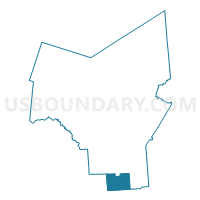
Voting District 190002, Oneida County, New York
About
Outline

Summary
| Unique Area Identifier | 633043 |
| Name | Voting District 190002 |
| County | Oneida County |
| State | New York |
| Area (square miles) | 29.90 |
| Land Area (square miles) | 29.72 |
| Water Area (square miles) | 0.18 |
| % of Land Area | 99.40 |
| % of Water Area | 0.60 |
| Latitude of the Internal Point | 42.89160650 |
| Longtitude of the Internal Point | -75.38022030 |
Maps


Graphs
Select a template below for downloading or customizing gragh for Voting District 190002, Oneida County, New York


Neighbors
Neighoring Voting District (by Name) Neighboring Voting District on the Map
- Voting District 010002, Madison County, NY
- Voting District 010003, Madison County, NY
- Voting District 050001, Oneida County, NY
- Voting District 110001, Madison County, NY
- Voting District 140001, Oneida County, NY
- Voting District 140002, Oneida County, NY
- Voting District 190001, Oneida County, NY
Top 10 Neighboring County Subdivision (by Population) Neighboring County Subdivision on the Map
- Madison town, Madison County, NY (3,008)
- Sangerfield town, Oneida County, NY (2,561)
- Brookfield town, Madison County, NY (2,545)
- Marshall town, Oneida County, NY (2,131)
- Bridgewater town, Oneida County, NY (1,522)
Top 10 Neighboring Place (by Population) Neighboring Place on the Map
Top 10 Neighboring Unified School District (by Population) Neighboring Unified School District on the Map
- Mount Markham Central School District, NY (7,273)
- Waterville Central School District, NY (5,820)
- Madison Central School District, NY (3,064)
- Brookfield Central School District, NY (1,459)
Top 10 Neighboring State Legislative District Lower Chamber (by Population) Neighboring State Legislative District Lower Chamber on the Map
Top 10 Neighboring State Legislative District Upper Chamber (by Population) Neighboring State Legislative District Upper Chamber on the Map
Top 10 Neighboring 111th Congressional District (by Population) Neighboring 111th Congressional District on the Map
Top 10 Neighboring Census Tract (by Population) Neighboring Census Tract on the Map
- Census Tract 310, Madison County, NY (5,319)
- Census Tract 256, Oneida County, NY (4,151)
- Census Tract 257, Oneida County, NY (2,561)
- Census Tract 311, Madison County, NY (2,545)
- Census Tract 258, Oneida County, NY (1,522)
Top 10 Neighboring 5-Digit ZIP Code Tabulation Area (by Population) Neighboring 5-Digit ZIP Code Tabulation Area on the Map
- 13480, NY (3,532)
- 13425, NY (1,970)
- 13402, NY (1,534)
- 13318, NY (1,325)
- 13485, NY (1,132)
- 13355, NY (905)
- 13418, NY (255)